Mitch Blank's North-German Genealogy Site

Let me know if we are researching the same people or places.


Name and place indexes for this entire web site.

Information on just Kreis Greifenberg, Pommern.

Introduction to this web site.
Copyright ©1998-2019 by Mitch Blank
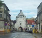
Greifenberg
(Now Gryfice)
Kreis Greifenberg, Pommern
(Click on picture for larger image)
Related Families in Greifenberg
Navigation
Let me know if we are researching the same people or places.
Name and place indexes for this entire web site.
Information on just Kreis Greifenberg, Pommern.
Introduction to this web site.
This page created December 11th, 2000, last updated June 25th, 2019
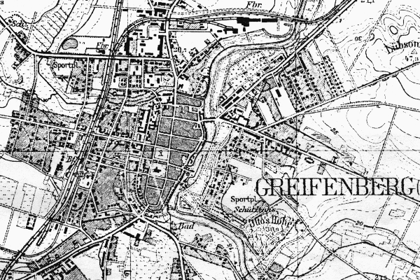
Kreis Greifenberg, Pommern
(Click on picture for larger image)
| |
| To zoom out to a larger area map click here. | |
|---|---|
Map dates from 1890, updated 1940. It covers an area of approximately 2.5 by 1.7 km (1.6 by 1.1 US miles).
Map image was adapted from 1:25K Prussian Landsaufnahme, page 2057
The following table shows which of the individuals included in this web site are connected to Greifenberg and over what time span they are found here.
| Surname | Given names and the range of dates the person was found in Greifenberg |
|---|---|
| Arbeit |
 Johann Wilhelm 1867 Johann Wilhelm 1867 |
| Blank |
 Ida 1925 Ida 1925 |
| Burand |
Friedrich Wilhelm 1852 |
| Parpart / Par(b/p/pp)ar(d/t/dt/th) |
 Caroline Charlotte 1859..1900 Caroline Charlotte 1859..1900 |
| Perkuhn |
Christian Adolph 1847..1859 Rudolf 1859..1904 Rudolf 1859..1904 |
| Wartgow |
Martin August 1852 |