Mitch Blank's North-German Genealogy Site

Let me know if we are researching the same people or places.


Name and place indexes for this entire web site.

Information on just Kreis Greifenberg, Pommern.

Introduction to this web site.
Copyright ©1998-2018 by Mitch Blank
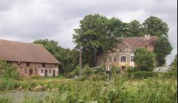
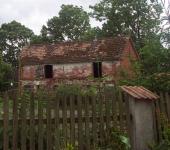
Darsow
(Now Darzewo)
Kreis Greifenberg, Pommern
(Click on picture for larger image)
Related Families in Darsow
Navigation
Let me know if we are researching the same people or places.
Name and place indexes for this entire web site.
Information on just Kreis Greifenberg, Pommern.
Introduction to this web site.
This page created June 16th, 2002, updated August 2nd, 2018, last edited September 24th, 2018
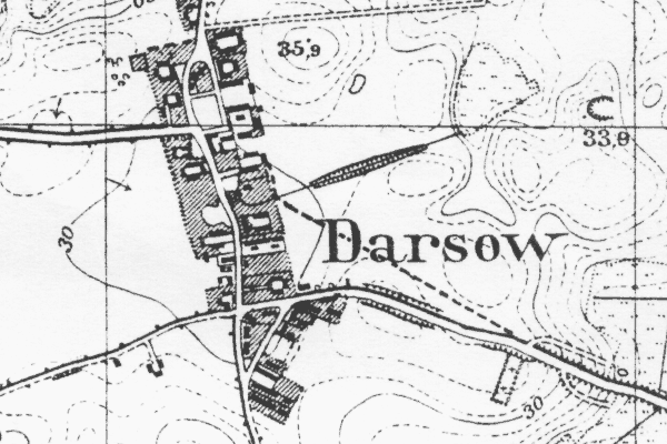
Kreis Greifenberg, Pommern
(Click on picture for larger image)
| |
| To zoom out to a larger area map click here. | |
|---|---|
Map dates from 1891, updated 1941. It covers an area of approximately 1.3 by 0.8 km (0.8 by 0.5 US miles).
Map image was adapted from 1:25K Prussian Landsaufnahme, page 1958
The following table shows which of the individuals included in this web site are connected to Darsow and over what time span they are found here.
| Surname | Given names and the range of dates the person was found in Darsow |
|---|---|
| Block |
 Heinrich Martin 1840 Heinrich Martin 1840 Heinrich Martin 1800..1847Maria 1854Peter 1797..1832 Heinrich Martin 1800..1847Maria 1854Peter 1797..1832 |
| Breger |
Catharina 1800 |
| Kressin / Krössin / Kroessin |
 August Wilhelm 1840Fredericka 1816Johann 1801..1874Marie 1822Martin 1818..1840Martin 1790..1830Martin 1782..1801 August Wilhelm 1840Fredericka 1816Johann 1801..1874Marie 1822Martin 1818..1840Martin 1790..1830Martin 1782..1801 |
| Pagenkopf |
Engel 1826..1880 |
| Polzin/Poltzin |
 August Friedrich Wilhelm 1843Johann 1825 August Friedrich Wilhelm 1843Johann 1825 |
| Radtke / Radke / Rathke |
Ludwig 1824 |
| Riess / Ries(c)h / Riehs |
Sophia 1832..1843 |
| Rüge |
Dorothea 1816..1822Engel 1786..1801 |
| Scheer/Schär |
 Hans 1830..1855Wilhelmine 1833..1855 Hans 1830..1855Wilhelmine 1833..1855 |
| Treptow |
Maria 1840 |