Mitch Blank's North-German Genealogy Site

Let me know if we are researching the same people or places.

Name and place indexes for this entire web site.
Information on just Western Mecklenburg.

Introduction to this web site.
Copyright ©1998-2017 by Mitch Blank
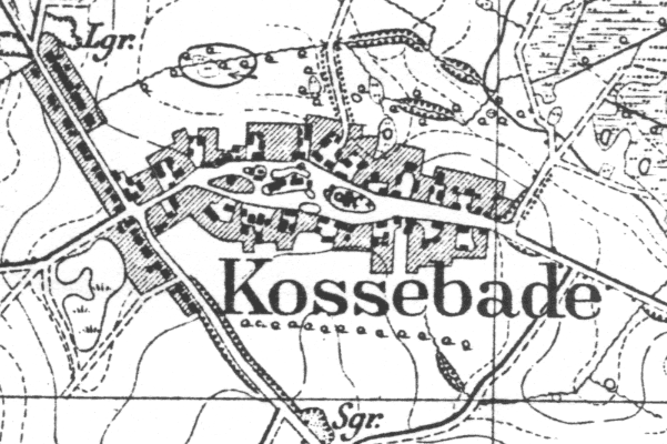
Kossebade
Kreis Parchim, Mecklenburg-Schwerin
Related Families in Kossebade
Navigation
Let me know if we are researching the same people or places.
Name and place indexes for this entire web site.
Information on just Western Mecklenburg.
Introduction to this web site.
This page created November 21st, 2007, updated March 8th, 2011
Kreis Parchim, Mecklenburg-Schwerin
| |
| To zoom out to a larger area map click here. | |
|---|---|
Map dates from 1882, updated 1919. It covers an area of approximately 1.3 by 0.8 km (0.8 by 0.5 US miles).
Map image was adapted from 1:25K Prussian Landsaufnahme, sheet 2437
The following table shows which of the individuals included in this web site are connected to Kossebade and over what time span they are found here.
| Surname | Given names and the range of dates the person was found in Kossebade |
|---|---|
| Augustin |
 Dorothea 1715 Dorothea 1715 |
| Dieterich |
 Catharina 1659..1707 Catharina 1659..1707 |
| Dun(c)ker |
 Christian 1683..1704Dorothea 1654..1704 Christian 1683..1704Dorothea 1654..1704 |
| E(h)lert |
Catharina 1665..1704Christian 1704..1714Dorothea 1661Hans 1659Hans 1659..1680Maria 1704 |
| Gottschal(c)k |
Ann Dorothea 1687..1704Catharina Elisabet 1696Christian 1692Hans 1698Hans 1687..1713Jochim Detloff 1702Maria 1690 |
| Schack |
Anna 1686 |
| Wahrman |
Hans 1646..1711 |